Showing posts with label QSPO. Show all posts

Sunday, June 11, 2023

Quilt Shops and Photo Ops

 Back in July of 2020, I started a second Instagram account, Quilt Shops and Photo Ops, to document the overlapping hobbies of my wife and I.  Over the next 13+ months, we were moderately active, with a range of photos taken on road trips, and/or sewing/quilting related.  Then life intruded, with job changes, family issues, etc.  Anyway, that IG went stagnant.  My other account, lsqrd42 never stopped completely, but did slow down for a bit.

Anyway, life eventually settled out, and work situation has been adjusted, and we're back to doing some of the things we were talking about 2 years ago.  So, about 6 weeks ago, I decided to restart QSPO.  The traffic (so far) has been modest (to be polite), but that's OK, it was pretty modest before.  On the other hand, if you wanted to give it a look (or a follow!), I sure wouldn't mind...


Now the web site?  We should probably pull the plug on that.  It never really got off the starting line, and I don't see that happening at this point...  Anyway, check out QSPO, let me know your opinion!


Thursday, September 24, 2020

I went away for a while, but I'm back now...

Just back from a week of travel.  7 days, 2,800 miles, 8 states.  Visited friends in Colorado, went to Mt. Rushmore, Badlands National Park, Buffalo Gap National Grassland, Black Hills National Forest, and more.  Oh, and stopped by 12 quilt shops along the loop. And took close to 400 photos!

From Illinois through Missouri, Kansas, Colorado, Wyoming, South Dakota, Nebraska, Iowa, Missouri back into Illinois.  Approximate map below:


Here's a better detail of our Sunday loop through Buffalo Gap National Grasslands, which was my foavortie part of the trip:


Look for more on this trip over the next few days!

Wednesday, August 26, 2020

Wawatam Lighthouse

 The Wawatam lighthouse is in Saint Ignace, Michigan, just across the Mackinac Bridge from Mackinaw City.  And its history is a little bit less auspicious than the other lighthouses we visited.

From wikipedia:  The current lighthouse was originally built in 1998 as an architectural folly at the Monroe Welcome Center on Interstate 75 in the southeastern corner of the state near the Ohio border. It was a functional lighthouse structure that was constructed far away from navigational waters as an element of the tourist heritage of the state. In 2004, the Welcome Center was renovated, and the lighthouse determined to be obsolete.  St. Ignace civic leaders applied to be the location of the small tower, and the lighthouse was trucked more than 330 miles to East Moran Bay in St. Ignace.  

After reassembly, the Wawatam Lighthouse was relit on August 20, 2006. The lighthouse is now an official United States Coast Guard privately maintained aid to navigation.

The tower is 52 feet tall, but rated it as 62 feet tall from the water.


Here's a snip from Google Earth, showing where the lighthouse and the passage light are  (not my photo!):


Tuesday, August 25, 2020

Round Island Lighthouse


The Round Island Lighthouse sits just 0.40 miles south of the Round Island Passage Light, the 


From wikipedia:  The Round Island Light, also known as the "Old Round Island Point Lighthouse" is a lighthouse located on the west shore of Round Island in the shipping lanes of the Straits of Mackinac. It was deemed necessary because the island is a significant hazard to navigation in the straits, and was seen as an effective complement to the other lights in the area. Because of its color scheme and form — red stone base and wood tower — it has been likened to an old-fashioned schoolhouse.  Ferries regularly pass it on their way to (and from) Mackinac Island, and it is a recognizable icon of the upper Great Lakes.

Round Island Lighthouse was constructed in 1895. The beacon was automated in 1924 and became the responsibility of the United States Coast Guard in 1939, when the Coast Guard took over all of the nation's lighthouses. To support World War II efforts, most of the original machinery on the first floor was removed for scrap.  The lighthouse was decommissioned in 1947, when the Round Island Passage Light was automated, and was transferred to Hiawatha National Forest in 1958.  

I thought it was really interesting that this lighthouse sits on a tiny island, about 500' from land.  But subsequent research reveals that the "island" effect id due to high water in the lakes.  It's even a high water emergency.


Here's a snip from Google Earth, showing where the lighthouse and the passage light are  (not my photo!):


Monday, August 24, 2020

Round Island Passage Light


Just outside the north breakwater at Mackinac Island, Round Island Passage Light is an automated, unmanned lighthouse located in the Round Island Channel in the Straits of Mackinac, Michigan.  Built in 1948 to mark the northern side of the navigable channel.  According to Wikipedia, the Passage Light was one of the last lights to be constructed on the Great Lakes, and was relighted as a private aid to navigation in 1996.

Still from wikipedia:  The Round Island Passage Light is constructed on a timber crib foundation which is 56 feet square. The timber crib has perimeter cells filled with concrete, and internal cells filled with rock. Atop the crib is a concrete superstructure with a 41-foot square reinforced concrete deck. The superstructure is octagonal, with four vertical and four sloping sides.  Atop the tower's concrete deck is a red-painted enclosure, 11-feet high.  Above the enclosure is a five-story octagonal steel tower, 41-1/2 feet high and 12 feet across. Each side of the tower contains a four-foot bronze relief Indian head, commemorating the fact that Mackinac Island was a sacred spot for Native American tribes. The light originally had a 47-foot steel antenna atop the tower, but it was removed in the early 2000s.


Here's a snip from Google Earth, showing where the lighthouse is.  (not my photo!):


Sunday, August 23, 2020

Mission Point Lighthouse

Mission Point Lighthouse sits on the end of a peninsula between the East arm and West arm of Grand Traverse Bay.  In Traverse City Michigan.

From the lighthouse's web site:  During the 1860’s a large ship hit a shallow reef and sank just in front of where Mission Point Lighthouse now sits. At this point that Congress set aside funds for the construction of the lighthouse. However, it wasn’t completed until 1870 due to the Civil War. From 1870 through 1933, Mission Point’s light kept the waters at the end of Old Mission Peninsula safe for mariners. It was in 1933 that the lighthouse was decommissioned and later replaced with an automatic buoy light just offshore.

Like many other lighthouses, whale oil (and later kerosene) was used to light the 5th Order Fresnel lens that refracted and magnified its modest light source into an intense beam that could be seen up to 13 miles away. The building was only one and one half stories tall. However, its placement on a sand bank 14 feet above the lake's surface created a lens focal plane of 47 feet. 


During our visit, the lighthouse tower was closed, but they have a small museum and gift shop which were open.  There are steps in front of the lighthouse down the dune to a small beach area.


- - - 

Here's a snip from Google Earth, showing where the lighthouse and the passage light are  (not my photo!):


Point Betsie Lighthouse

Continuing the review of lighthouses from our recent trip to northern Michigan.  Today we'll look at Point Betsie Lighthouse, in Mackinaw City, Michigan.


Point Betsie Light is located on the northeast shore of Lake Michigan — at the southern entrance to the Manitou Passage.  Established in 1858, it was automated in 1983.  The lighthouse sits on a dune, with a concrete "seawall" in front.  The tower is 39' tall, and the high base, the light could be seen for 24 nautical miles.

This oldest standing structure in Benzie County, built in 1858, it marks the all-important entrance to southern end of the Manitou Passage, a once-vital maritime shipping channel. Although the lane is no longer used by large commercial vessels, the operating light signal remains a US Coast Guard aid to navigation to this day, and the site shines as a treasured landmark to mariners and landlubbers alike. 


The building and immdeiate grounds were close when we were there, but we were able to wander around the area, including the public beach immediately to the south of the lighthouse.


Here's a snip from Google Earth, showing where the lighthouse is.  (not my photo!):


Saturday, August 22, 2020

Old Mackinac Point Lighthouse

 Continuing the review of lighthouses from our recent trip to northern Michigan.  Today we'll look at Old Mackinac Point Lighthouse, in Mackinaw City, Michigan.


Located at the northern tip of the main part of Michigan (not UP!), the Mackinac Point Lighthouse sits on the south side of the Straits Of Mackinac, between Lake Michigan and Lake Huron.  Built in 1889, the lighthouse was active until 1957, when the Mackinac Bridge (with its light) opened.    It's now a historic site.

We arrived in Mackinaw City as the sun was setting, and decided to try and catch the last rays (above).  The lighthouse is obviously in the center, the building on the right is the Fog Signal building, and the Warehouse is on the left.  You can see the low part of the Mackinac Bridge between the buildings...


Another photo in the fading light...


The next day we took the Ferry to Mackinac Island, and s able to see the lighthouse from the strais:


Here's a snip from Google Earth, showing where the lighthouse is.  (not my photo!):


Friday, August 21, 2020

Ludington Breakwater Lighthouse

One of the goals of our recent trip to Northern Michigan (not UP!) was to visit some of the lighthouses long the shores of Lake Michigan and Lake Huron.  I thought I'd post them here, with a short explanation:

Ludington Breakwater Lighthouse, Ludington, MI


This was the last lighthouse we visited before heading home.  It sits t the end of the northern breakwater protecting the entrance to Pere Marquette Harbor, in Ludington, Michigan.  Built in 1924, automated in 1972, and still You can walk out the breakwater (about 0.5 mi) to the lighthouse, but we chose not to, as it was threatening to rain.

I first saw this lighthouse from Ludington State Park, where we did a short explore of the dunes.  We did NOT make it to the Big Sabel Lighthouse there, as it was a 2 mile walk, and cost monet to enter that part of the park.  That did fit this trip (especially the 4 mile walk when we had 700 miles of driving in front of us).  Anyway, the dunes are cool.


Below is a shot from about 3 miles north of the Luddington Lighthouse, from the state park:


Here's a snip from Google Earth, showing where the lighthouse is.  (not my photo!):


Wednesday, August 19, 2020

I went Away For A While...

 But I'm back now!


Sorry folks, been a bit crazy, a bit unfocused....  and perhaps a bit lazy.  Time to make it up!


We took a quick (well, quick-ish) trip to northern Michigan recently, on the Quilt Shops and Photo Ops side of things.  You can look at that blog for more details...  Anyway, between being on the road, and wading though over 300 images, I'm overloaded.  

But have no fear, folk.  I have no plans to cut back here.  

The photo above is from the ferry crossing the Straits of Mackinac on one of the ferries to Mackinac Island.  I was trying to capture the sense of motion, how'd I do?


Sunday, July 12, 2020

Engine House Ruin


Took a day trip to Elephant Rocks State Park, not quite 2 hrs from home. Cool place, if a bit crowded... One of the side trails led to this 1890's era Engine House, built to house the train locomotives that hauled granite from the quarry nearby to St. Louis and points beyond.

As much as I love my Fujifilm X-T3, sometimes the iPhone gets the better shot... This is one of those times.  The inherent wide angle worked well here.

From a Quilt Shops and Photo Ops outing.


Tuesday, July 07, 2020

Where thrills become as cheap as gas (and gas as cheap as thrills)


Near Treloar, MO along the Missouri River bottomlands. This is Rt. 94, 60-65 miles west of St. Louis. The Missouri River is about 1.5 miles off tto the right, the hills in the distance are on the other side of the river.

From a "Quilt Shops and Photo Ops" excursion with my wife, first time in a while that we've managed that, with the pandemic lock down and all.  This version was mostly driving, only one quilt shop (in O'Fallon, MO).  Still, nice to get out, spend some windshield time...

The title is from the old Blue Oyster Cult song "Before The Kiss, A Redcap".  Which doesn't really fit the mood of this photo.  But I thought the lyrics fit nicely with the "road trip" aspect of the day.

Friday, December 06, 2019

Old Barn, A bit battered...


So, a find on a back road, A few miles north of Hamilton MO. Which is a ways NE of Kansas City, MO.  Taken back in October, during our Quilt-Shops-And -Photo-Ops excursion across Missouri.

We were wandering out of Hamilton looking for a little shop in the middle of nowhere (which we did find).  When we saw this barn, we pulled to the side of the road to let me wander for the best angle.  What's here was the best I could manage.


UPDATE:
My wife snaped an iPhone shot of me scouting the composition:


Tuesday, October 29, 2019

Locust Creek Covered Bridge


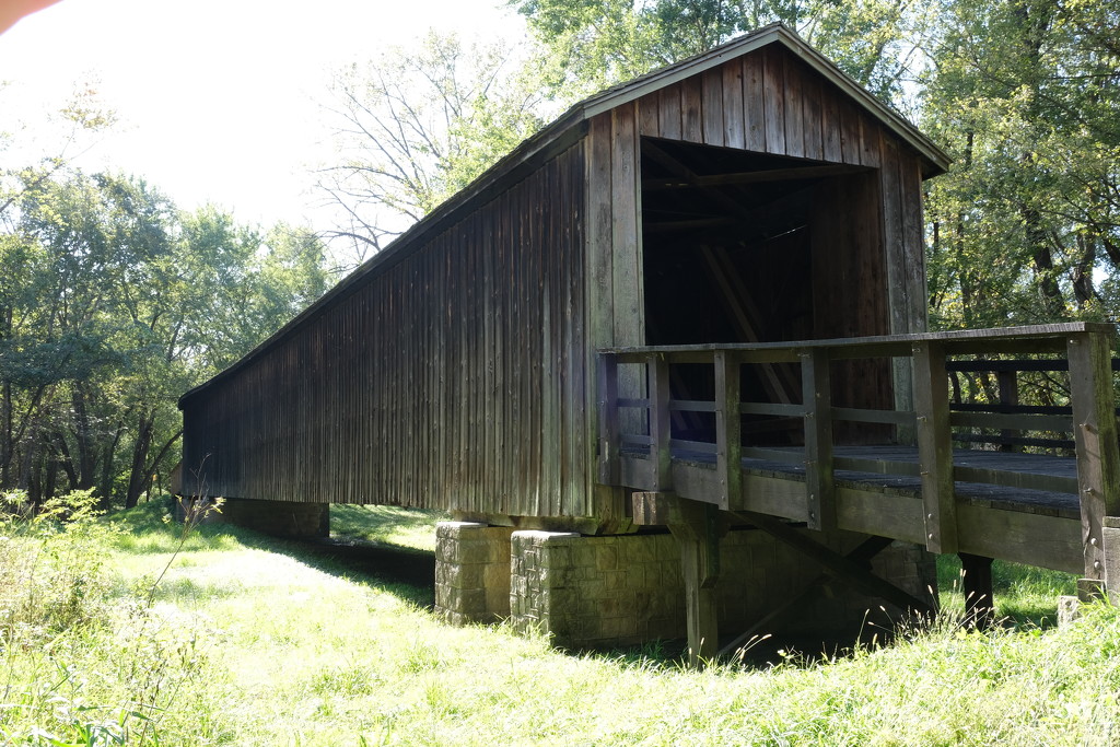
A couple of weeks ago the wife and I took a weekend jaunt.  From St. Louis over to KC, and then wandering back (via Hannibal, MO).  A "Quilt shops and Photo Ops" excursion. 

On the Eastbound drive, Driving across Missouri on Rt 36, we saw a brown sign" for Locust Creek Covered Bridge. A short drive off the highway, and a short walk later, we found this cool old covered bridge.  The bridge was built in 1868, and is apparently the longest of Missouri's four remaining covered bridges. These days, not only has the road moved, but also the creek, so it provides a walkway across a dry depression. Still cool.  History here.

I took this photo with my iPhone, mostly to get gps coordinates.  But I decided to play with this version using the processing tools on my phone, and was happy with the result.  Mostly the free ap Snapseed.  There's actually quite a bit of tweaking, trying to get an "old time" feel.

Here's the original "SOOC" version, for comparison, complete with finger edging into the top-left corner:


I entered this into the ETSOOI contest at 365project, and it made finalist.  Yay!


Monday, October 14, 2019

Envy

Just a little something seen in Liberty, Missouri.  I was wandering around Liberty Missouri while my wife was shopping at a Quilt shop.  This is just across Water Street from the Clay County Courthouse.

Pretty much SOOC, except for rotating to get the light post straight.  Modified in a hotel room on my iPad, but taken with mu Fujifilm X-T3.


Why "Envy"??  IWell....  why NOT?  I guess it is just a thought inspired by the green wall in the background.  Trying not to overthink it.

Saturday, January 26, 2019

Chessie's Girl...


Pardon the bad pun reference to the best forgotten 1981 Rick Springfield song.  You know it is locked into your head now.  I know it is in mine. If not, try this link to seal the deal.

This is an oldie, from back in August 2018, that managed to fall through the cracks f my mind.  I actually have a lot of unprocessed images from that trip, maybe you'll see some more...

Taken in Staunton VA, seen while looking for a quilt shop w/ the wife.  We had a nice lunch rather nearby.


Tuesday, October 16, 2018

Beaver Dam State Park

Last Saturday, we were looking for an excursion.  Not too far from home, but someplace we hadn't already been 1,000 times.  Looking at the map on my phone, I noticed a small-ish splotch of green about 45 minutes north of us.  Scrolling in, I see Beaver Dam State Park in Plainview, IL.  Quick google, and it looks like a good candidate.  And close enough to Staunton for a quilt shop side trip.

A nice drive, and a nice park.  Not huge, but calm and peaceful.  And a few photos to boot.  Click for larger versions.


We spent a while wandering the site, enjoying the (rather cool) October day.  I want to go back sometime and check out all of the trail around the lake, they said (at the concession stand) it is about 3 miles.  And the concession stand even had a wine tasting from Plainview Vinyard and Winery.  So we had a few tastes, and picked up a bottle to go with our evening meal.

This one is from just 1.5 miles or so northest of the park....


Sunday, October 07, 2018

Trenton, KY

Our last quilt shop during our recent travels was in Trenton, KY.  This led us on a great "Blue Highways" excursion around Nashville, with lots of fun scenes (stay tuned for those!).  And we found a really cool shop:  Quilt and Sew at Golden Threads.  And while my wife shopped, I wandered.  And found some photo ops that I'm pretty satisfied with.  So here you go:

Click for larger versions


Of course, I'm drawn to the old and worn...  The town of Trenton was nice, I just photographed the ragged edges.  

I Went Away For A While, But I'm Back Now.....

Sorry for the lack of posts recently, but we've been travelling.  The wife and I were on a road trip to celebrate our wedding anniversary:  Quilt Shops and Photo Ops!  I didn't take a computer, so posting had to wait.  I do hope y'all will forgive me.

OTOH, I have a LOT of images to plow through, so I ought to be posting a good bit in the new few days.

So, here's our route, or at least the high points.  We started with a two day run to Raleigh-Durham, NC, splitting the drive in Hillsville, VA,  Then a quick stop at Duke, where we met, courted and married.  And a visit with my daughter and her SO in Raleigh.


Then off to Charleston, SC, where we spent most of the week doing the tourist thing.  We split the drive home in Newport, TN, with a quick stop at the Folk Art Center in Asheville, NC.  And a really fun bypass on "blue highways" around Nashville.  And Quilt Shops in Summerville, SC, Dandridge, TN, Crossville, TN, Trenton, KY...  there may be a couple more, need to check w/ the wife.

We passed through 8 states:  Illinois, Indiana, Kentucky, West Virginia, Virginia, North Carolina, South Carolina, and Tennessee.  And looking at Google maps the loop was just under 2,000 miles,   By the odometer, we only went about 250 miles more than that, but we did a ton of walking in Charleston.

So now it is back to the grind, with some great memories and lots of unprocessed photos. 

Stay tuned!

Thursday, September 13, 2018

Southern Indiana Explore...

From our trip last month, I'm still working through the photos.  A fun explore: after spending the night in Corydon, Indiana (about 25 miles west of Louisville) we decided to NOT jump back on the interstate, and to wander the backroads for a bit.  

Our first stop was The Overlook at Leavenworth, Indiana.  We had a most-enjoyable lunch here probably 10 years ago [edit, looks like June of 2009].  This day we were there before the restaurant opened, but we enjoyed looking over the overlook:


And the view, looking upriver (with lots of effects).  It was a bit cloudy, and quite windy (see flag above), but not at all unpleasant....


- - - - -


Eventually we found ourselves here...  A 1-lane bridge across the Little Blue River.  A bit south of the unincorporated community of Beechwood, Indiana.


The blue sign at the lower right says

NOTICE
 Historic bridge ahead
 May be replaced
 For more information
 call
(812) 338-2162

I kind of wanted to call, but didn't.  The weight limit was 8 tons, which doesn't seem too bad.

- - - - -

Continuing along took us to Alton, Indiana.  Not to be confused with Alton, IL...  A small town, population 55.  Sitting right on the Ohio River, though.  There were quite a few campers parked near the river, I got the impression they were weekend homes rather than folks passing through.  thye just had a "settled" look.  But they did have a dock.  Of sorts:


The town was laid out in a small grid, and all of the streets were (barely) one lane wide (but not one-way).  The photo isn't really meant to tell a story about Alton, I just like dead tech...  Here's a longer view, you can see that it was still pretty overcast...


- - - - -

Continuing on our wander, we next stopped at the unincorporated community of Magnet, just around the next river bend.  Looking south on the Ohio River...  the clouds were just starting to break up.


 - - - - -

All in all, a really pleasant side trip.  It added a couple of hours to our return trip, but was time well spent.